
SMP IT MARHAMAH
| Nama | : | SMP IT MARHAMAH | |
| NPSN | : | 69986564 | |
| Alamat | : | Jl. Sawah Kareh Jorong Batng Limpaung | |
| Desa/Kelurahan | : | PAKAN RABAA TENGAH | |
| Kecamatan/Kota (LN) | : | KEC. KOTO PARIK GADANG DIATEH | |
| Kab.-Kota/Negara (LN) | : | KAB. SOLOK SELATAN | |
| Propinsi/Luar Negeri (LN) | : | PROV. SUMATERA BARAT | |
| Status Sekolah | : | SWASTA | |
| Bentuk Pendidikan | : | SMP | |
| Jenjang Pendidikan | : | DIKDAS |
| Kementerian Pembina | : | Kementerian Pendidikan, Kebudayaan, Riset dan Teknologi | |
| Naungan | : | Yayasan Pendidikan dan Da''wah Islam Marhamah | |
| NPYP | : | AB8578 | |
| No. SK. Pendirian | : | AHU-00748.AH.02.01.TAHUN 2017 | |
| Tanggal SK. Pendirian | : | 14-08-2018 | |
| Nomor SK Operasional | : | 911/01/IZIN-SMP/XII-2018 | |
| Tanggal SK Operasional | : | 11-12-2018 | |
| File SK Operasional () | : | Lihat SK Operasional | |
| Tanggal Upload SK Op. | : | 29-07-2019 14:24:58 | |
| Akreditasi | : | C |
| Luas Tanah | : | 250.000 m2 | |
| Akses Internet | : | 1. - | |
| : | 2. 1 Mb | ||
| Sumber Listrik | : | PLN |
| Fax | : | - | |
| Telepon | : | ||
| : | smpitmarhamah_solsel@yahoo.com | ||
| Website | : | http://smpitmarhamah.blogspot.com | |
| Operator | : | Ida Yatul Ukhra, S.Pd |
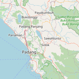


Leaflet | © OpenStreetMap
Lintang: -1.413732000000
Bujur: 100.999762000000
Bujur: 100.999762000000