
SMP NEGERI 58 BATAM
| Nama | : | SMP NEGERI 58 BATAM | |
| NPSN | : | 69981472 | |
| Alamat | : | Jl. Raya Kampung Bagan Sei Daun | |
| Desa/Kelurahan | : | TANJUNG PIAYU | |
| Kecamatan/Kota (LN) | : | KEC. SEI BEDUK | |
| Kab.-Kota/Negara (LN) | : | KOTA BATAM | |
| Propinsi/Luar Negeri (LN) | : | PROV. KEPULAUAN RIAU | |
| Status Sekolah | : | NEGERI | |
| Bentuk Pendidikan | : | SMP | |
| Jenjang Pendidikan | : | DIKDAS |
| Kementerian Pembina | : | Kementerian Pendidikan, Kebudayaan, Riset dan Teknologi | |
| Naungan | : | Pemerintah Daerah | |
| NPYP | : | - | |
| No. SK. Pendirian | : | 1443/420.2/DISDIK/VII/2018 | |
| Tanggal SK. Pendirian | : | 18-07-2018 | |
| Nomor SK Operasional | : | KPTS. 248/HK/VIII/2018 | |
| Tanggal SK Operasional | : | 21-08-2018 | |
| File SK Operasional () | : | Lihat SK Operasional | |
| Tanggal Upload SK Op. | : | 22-10-2018 10:55:54 | |
| Akreditasi | : | B |
| Luas Tanah | : | 2.422 m2 | |
| Akses Internet | : | 1. - | |
| : | 2. 40 Mb | ||
| Sumber Listrik | : | PLN |
| Fax | : | - | |
| Telepon | : | ||
| : | smpn58sbd@gmail.com | ||
| Website | : | http://smpn58batam.co.id | |
| Operator | : | MUHAMAD FIRDAUS |
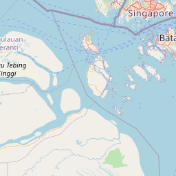


Leaflet | © OpenStreetMap
Lintang: 1.038900000000
Bujur: 104.096300000000
Bujur: 104.096300000000