
MIN 1 KEPULAUAN SANGIHE
| Nama | : | MIN 1 KEPULAUAN SANGIHE | |
| NPSN | : | 60723356 | |
| Alamat | : | KAMPUNG BEHA | |
| Desa/Kelurahan | : | PUSUNGE | |
| Kecamatan/Kota (LN) | : | KEC. TABUKAN UTARA | |
| Kab.-Kota/Negara (LN) | : | KAB. KEP. SANGIHE | |
| Propinsi/Luar Negeri (LN) | : | PROV. SULAWESI UTARA | |
| Status Sekolah | : | NEGERI | |
| Bentuk Pendidikan | : | MI | |
| Jenjang Pendidikan | : | DIKDAS |
| Kementerian Pembina | : | Kementerian Agama | |
| Naungan | : | Pemerintah Daerah | |
| NPYP | : | - | |
| No. SK. Pendirian | : | ||
| Tanggal SK. Pendirian | : | - | |
| Nomor SK Operasional | : | - | |
| Tanggal SK Operasional | : | - | |
| File SK Operasional () | : | Silakan Upload SK | |
| Tanggal Upload SK Op. | : | - | |
| Akreditasi | : | A |
| Luas Tanah | : | 0 m2 | |
| Akses Internet | : | 1. | |
| : | 2. | ||
| Sumber Listrik | : | - |
| Fax | : | - | |
| Telepon | : | ||
| : | |||
| Website | : | ||
| Operator | : | Sapiat Tondongseke |
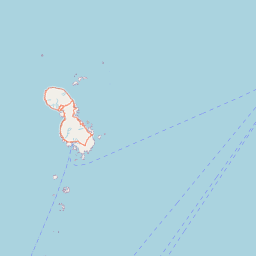

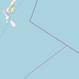


Leaflet | © OpenStreetMap
Lintang: 3.653193000000
Bujur: 125.490835000000
Bujur: 125.490835000000