
SMP SATU ATAP DATAH
| Nama | : | SMP SATU ATAP DATAH | |
| NPSN | : | 50104104 | |
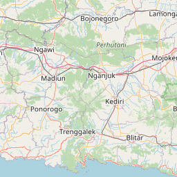
| Alamat | : | Banjar Dinas Kedampal | |
| Desa/Kelurahan | : | DATAH | |
| Kecamatan/Kota (LN) | : | KEC. ABANG | |
| Kab.-Kota/Negara (LN) | : | KAB. KARANG ASEM | |
| Propinsi/Luar Negeri (LN) | : | PROV. BALI | |
| Status Sekolah | : | NEGERI | |
| Bentuk Pendidikan | : | SMP | |
| Jenjang Pendidikan | : | DIKDAS |
| Kementerian Pembina | : | Kementerian Pendidikan, Kebudayaan, Riset dan Teknologi | |
| Naungan | : | Pemerintah Pusat | |
| NPYP | : | - | |
| No. SK. Pendirian | : | 306 Tahun 2008 | |
| Tanggal SK. Pendirian | : | 08-06-2009 | |
| Nomor SK Operasional | : | Perbup No 64 Tahun 2020 | |
| Tanggal SK Operasional | : | 30-12-2020 | |
| File SK Operasional () | : | Lihat SK Operasional | |
| Tanggal Upload SK Op. | : | 17-05-2024 20:14:29 | |
| Akreditasi | : | B |
| Luas Tanah | : | 1.980 m2 | |
| Akses Internet | : | 1. - | |
| : | 2. 300 Mb | ||
| Sumber Listrik | : | PLN |
| Fax | : | - | |
| Telepon | : | ||
| : | sdsmpsatapdatah5@gmail.com | ||
| Website | : | ||
| Operator | : | I GEDE ERY SUHARTAWAN,S.Pd., M.Pd. |
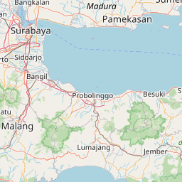


Leaflet | © OpenStreetMap
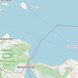
Lintang: -8.348900000000
Bujur: 115.581000000000
Bujur: 115.581000000000