
SMP YP 17 SELOREJO
| Nama | : | SMP YP 17 SELOREJO | |
| NPSN | : | 20551753 | |
| Alamat | : | Jl. Raya Selorejo no 47 Rt 02 RW 02 | |
| Desa/Kelurahan | : | SELOREJO | |
| Kecamatan/Kota (LN) | : | KEC. SELOREJO | |
| Kab.-Kota/Negara (LN) | : | KAB. BLITAR | |
| Propinsi/Luar Negeri (LN) | : | PROV. JAWA TIMUR | |
| Status Sekolah | : | SWASTA | |
| Bentuk Pendidikan | : | SMP | |
| Jenjang Pendidikan | : | DIKDAS |
| Kementerian Pembina | : | Kementerian Pendidikan, Kebudayaan, Riset dan Teknologi | |
| Naungan | : | YAYASAN PENDIDIKAN 17 JAWA TIMUR | |
| NPYP | : | AH1300 | |
| No. SK. Pendirian | : | 6 April 1969 No. 11 | |
| Tanggal SK. Pendirian | : | 15-07-1959 | |
| Nomor SK Operasional | : | B/421.3/3167/409.10.4/2022 | |
| Tanggal SK Operasional | : | 30-08-2022 | |
| File SK Operasional () | : | Lihat SK Operasional | |
| Tanggal Upload SK Op. | : | 18-08-2023 13:23:58 | |
| Akreditasi | : | B |
| Luas Tanah | : | 1.700 m2 | |
| Akses Internet | : | 1. - | |
| : | 2. 50 Mb | ||
| Sumber Listrik | : | PLN |
| Fax | : | - | |
| Telepon | : | 0342332533 | |
| : | smpyp@rocketmail.com | ||
| Website | : | ||
| Operator | : | SITI KOMARIAH |
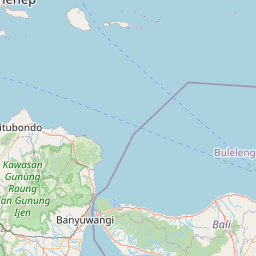

Leaflet | © OpenStreetMap
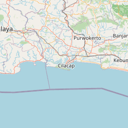
Lintang: -8.135500000000
Bujur: 112.422000000000
Bujur: 112.422000000000