
SMAS MUHAMMADIYAH TG PANDAN
| Nama | : | SMAS MUHAMMADIYAH TG PANDAN | |
| NPSN | : | 10900457 | |
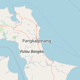
| Alamat | : | JL. JEND SUDIRMAN KM. 4 AIR RAYA | |
| Desa/Kelurahan | : | AIK RAYAK | |
| Kecamatan/Kota (LN) | : | KEC. TANJUNG PANDAN | |
| Kab.-Kota/Negara (LN) | : | KAB. BELITUNG | |
| Propinsi/Luar Negeri (LN) | : | PROV. KEPULAUAN BANGKA BELITUNG | |
| Status Sekolah | : | SWASTA | |
| Bentuk Pendidikan | : | SMA | |
| Jenjang Pendidikan | : | DIKMEN |
| Kementerian Pembina | : | Kementerian Pendidikan, Kebudayaan, Riset dan Teknologi | |
| Naungan | : | Yayasan Pimpinan Wilayah Muhammadiyah (PWM) Prov. Kepulauan Bangka Belitung | |
| NPYP | : | AJ5259 | |
| No. SK. Pendirian | : | 018/C/Kep/1.1983 | |
| Tanggal SK. Pendirian | : | 23-02-1983 | |
| Nomor SK Operasional | : | 234/I11.4/F4e/1988 | |
| Tanggal SK Operasional | : | 25-04-1988 | |
| File SK Operasional () | : | Lihat SK Operasional | |
| Tanggal Upload SK Op. | : | 31-08-2023 23:07:17 | |
| Akreditasi | : | B |
| Luas Tanah | : | 5.280 m2 | |
| Akses Internet | : | 1. - | |
| : | 2. 50 Mb | ||
| Sumber Listrik | : | PLN |
| Fax | : | 07199222140 | |
| Telepon | : | ||
| : | smamuhammadiyah79@yahoo.co.id | ||
| Website | : | http://10900457.siap-sekolah/ | |
| Operator | : | NUR IZZA ARIFAH |

Leaflet | © OpenStreetMap
Lintang: -2.744701700000
Bujur: 107.666695000000
Bujur: 107.666695000000