
SMP SINT CAROLUS KOTA BENGKULU
| Nama | : | SMP SINT CAROLUS KOTA BENGKULU | |
| NPSN | : | 10702526 | |
| Alamat | : | Jl. Todak No. 162 | |
| Desa/Kelurahan | : | SUMUR MELELE | |
| Kecamatan/Kota (LN) | : | KEC. TELUK SEGARA | |
| Kab.-Kota/Negara (LN) | : | KOTA BENGKULU | |
| Propinsi/Luar Negeri (LN) | : | PROV. BENGKULU | |
| Status Sekolah | : | SWASTA | |
| Bentuk Pendidikan | : | SMP | |
| Jenjang Pendidikan | : | DIKDAS |
| Kementerian Pembina | : | Kementerian Pendidikan, Kebudayaan, Riset dan Teknologi | |
| Naungan | : | Yayasan Tarakanita | |
| NPYP | : | AA0096 | |
| No. SK. Pendirian | : | 87/IMB/1993 | |
| Tanggal SK. Pendirian | : | 01-08-1954 | |
| Nomor SK Operasional | : | 421.2/1045/IV.DIKBUD | |
| Tanggal SK Operasional | : | 01-01-1910 | |
| File SK Operasional () | : | Lihat SK Operasional | |
| Tanggal Upload SK Op. | : | 01-09-2020 06:34:06 | |
| Akreditasi | : | A |
| Luas Tanah | : | 12.390 m2 | |
| Akses Internet | : | 1. - | |
| : | 2. 300 Mb | ||
| Sumber Listrik | : | PLN |
| Fax | : | 073624493 | |
| Telepon | : | 073621645 | |
| : | smp_carolus_bengkulu@yahoo.co.id | ||
| Website | : | http://https://tarakanita.sch.id | |
| Operator | : | MURIDI |


Leaflet | © OpenStreetMap
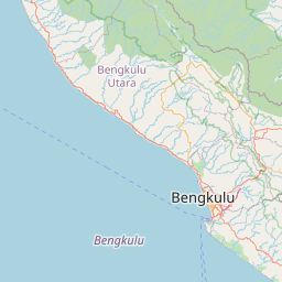
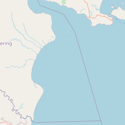
Lintang: -3.793300000000
Bujur: 102.250200000000
Bujur: 102.250200000000