
SD NEGERI 004 SIMPANG PULAI UKUI
| Nama | : | SD NEGERI 004 SIMPANG PULAI UKUI | |
| NPSN | : | 10404739 | |
| Alamat | : | Simpang Pulai | |
| Desa/Kelurahan | : | UKUI SATU | |
| Kecamatan/Kota (LN) | : | KEC. UKUI | |
| Kab.-Kota/Negara (LN) | : | KAB. PELALAWAN | |
| Propinsi/Luar Negeri (LN) | : | PROV. RIAU | |
| Status Sekolah | : | NEGERI | |
| Bentuk Pendidikan | : | SD | |
| Jenjang Pendidikan | : | DIKDAS |
| Kementerian Pembina | : | Kementerian Pendidikan, Kebudayaan, Riset dan Teknologi | |
| Naungan | : | Pemerintah Daerah | |
| NPYP | : | - | |
| No. SK. Pendirian | : | 421/SD-004/X/1986/4 | |
| Tanggal SK. Pendirian | : | 31-12-1986 | |
| Nomor SK Operasional | : | 421/SD-04/I/2015/05 | |
| Tanggal SK Operasional | : | 22-01-2015 | |
| File SK Operasional () | : | Silakan Upload SK (link file tidak valid) => [753495-874327--] | |
| Tanggal Upload SK Op. | : | 11-01-2023 09:48:43 | |
| Akreditasi | : | B |
| Luas Tanah | : | 9.450 m2 | |
| Akses Internet | : | 1. - | |
| : | 2. - | ||
| Sumber Listrik | : | PLN |
| Fax | : | - | |
| Telepon | : | ||
| : | sdn.004simpangpulai@gmail.com | ||
| Website | : | ||
| Operator | : | MUHAMMAD FADIL |
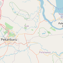
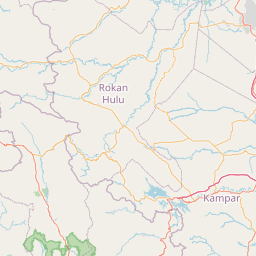


Leaflet | © OpenStreetMap
Lintang: -.101500000000
Bujur: 102.123800000000
Bujur: 102.123800000000